
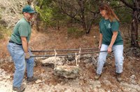
Trail Tamers at Bastrop State Park (report by Vick Hines, Crew Leader)
The Bastrop State Park project was a great success despite the weather and OU Weekend. We had about 25 folks helping out and put in over 180 hours of trail work. It looks as if we now have a good relationship with BSP, and hope to have other working weekends in the Spring and throughout next year. The following gives the details.
Summary of Trail Tamers work 11/28 - 12/5/09:
Trail Tamer crews worked 179 hours. Social trails located mainly inside PR1A were renaturalized. All other trails were brushed and social trails were renaturalized. Approximately 10 percent of problem slopes on the trail system were graded, side burms removed and drain swales installed. At least 10 creek crossings were cleaned and channelized and crossing aids installed. Two relocations were completed totaling 150 yards of improved trail. Several relocations are recommended for your consideration in addition to currently scheduled relocations.
11/28: 15 volunteers @ 6 hrs ea. = 90 hours
Red, green, white, black trails; renaturalized social trails.
Black Trail; installed drain and burm.
Blue trail E. of power line; Brushing and creek crossings, general trail maintenance, relocation of washed out trail section, renaturalization of old trail,
11/29: 3 volunteers @ 6 hrs ea. = 18 hrs
South Blue trail, Harmon Rd. to power line and Blue north, power line to Harmon, brushing, burm and drains, social trails, campfire debris removal.
11/30: 1 volunteer @ 6 hrs = 6 hrs.
Black trail, burm and drain (removal of concrete pour preventing proper drainage), Grey trail, burm and drains.
12/1: 1 vol @ 5 hrs = 5 hrs
Roosevelt’s Cutoff, brushing; N. Blue trail West to old road, brushing; S. Blue trail W. of Harmon Rd., deadfalls and social trails.
12/2: 1 vol @ 5 hrs = 5 hrs.
N. Blue trail from Harmon Rd. E., brushing and drains.
12/3: 2 vols. @ 5 hrs = 10 hrs.
Blue trail loop E. of power line, 5 creek crossings channelized and rocked, social trails concealed, brushing.
12/4: 2 vols. @ 5 hrs = 10 hr.
N. Blue trail E. of fence line, drains and burms on downslope.
12/5: 7 vols @ 5 hrs = 35 hrs
Green trail, relocated c. 120 yds of trail with dips and drains, relocated trail marker post, renaturalized old trail, channelized and rocked 3 creek crossings, removed debris from creeks.
Suggested Trail Relocations
Blue Loop E. of power line: At the far eastern end, after the southmost creek crossing, the trail is easily confused with a fire break and the approach to the creek crossing is heavily eroded. Recommend a relocation diverging from the existing trail approximately 35 yards west-southwest of current intersection with the fire break and rejoining the existing trail at or near the current creek crossing. This location would permit a lower gradient as it descends to the creek and would avoid confusion with the fire break entirely. Check steps would still be required for the descent.
N. Blue Trail approx. 0.25 to 0.5 miles E. of Gotier Trace Remnant. Several sections of this trail are 0˚ to the slope. Recommend replacing these sections with properly graded side hill segments.
N. Blue Trail, 0.25 mir. W. of Harmon Rd. receives surface and near surface runoff from both Harmon Rd. and an adjacent slope. Recommend relocation up the slope with an undulating side hill trail rejoining the existing trail at the next drainage west.
S. Blue Trail from the power line to 0.25 mi.W. of the power line is 0˚ to the slope and heavily guttered, ending in a poorly drained area that includes the last several yards of the new relocation which diverts the trail from the nearby pond. Recommend constructing a side hill trail from the power line north of the existing trail, intersecting the latest relocation on high ground.
S. Blue Trail from Scout Area to Roosevelt’s Cutoff is heavily guttered due to poor location. Several superior locations are available for each problem segment.
Roosevelt’s Cutoff. The southern 150 yards of the trail are 0˚ to the slope in sugar sand and heavily guttered. Recommend relocation east to rejoin existing trail at next drainage.
Grey Trail, E. of intersection w/ Red Trail is currently down-slope in an old road bed and heavily guttered. Recommend relocation up slope to N. 25 to 50 yards.
Subscribe to:
Post Comments (Atom)

No comments:
Post a Comment